
The modern utility locating landscape, encompassing contract locating and specialized Subsurface Utility Engineering (SUE) projects, hinges on a single critical deliverable: accurate, comprehensive spatial data. Moving beyond the historical method of simply marking utilities on the pavement, today’s industry demands verifiable, digital mapping. Geographic Information Systems (GIS) provide the foundational framework for this requirement, serving as the central repository for asset management, planning, and design. For utility owners, contract locators, and engineering firms, GIS is essential for integrating utility data into design plans, minimizing excavation risk, and ensuring compliance with standards like ASCE 38-22, making it the indispensable backbone of all subsurface risk mitigation.
Within this mapping framework, Ground Penetrating Radar (GPR) and its advanced counterpart, Multi-Channel GPR (MCGPR), are vital non-destructive tools for comprehensive subsurface data acquisition. Traditional utility locating often relies on electromagnetic (EM) methods followed by the ephemeral “locate-and-paint” approach, which provides temporary markings for immediate excavation. In contrast, GPR is used specifically for verifiable, permanent subsurface data and archived mapping. MCGPR, with its broad antenna arrays, generates massive, high-density 3D data volumes across vast areas, far exceeding the capability of single-channel GPR. This high-resolution data is crucial for asset owners that want to inventory their network or grid, and for Subsurface Utility Engineering (SUE) projects, where the goal is to create a digital, three-dimensional model of all buried assets, thereby transforming temporary field markings into permanent, georeferenced spatial records that can be used to create design plans. For contract locating, this inventory can be imported into a mobile GIS application that field technicians can continue to reference while making them more efficient, effective, and most importantly safe.
Despite its potential, the use of GPR for comprehensive mapping has historically faced significant barriers to entry that have kept it in the domain of specialists. The cost of advanced GPR and MCGPR equipment is substantial, but the largest hurdles are technical and educational. Proper GPR data interpretation requires specialized expertise, often rooted in advanced degrees in geophysics, geology, or engineering, to distinguish genuine utility signatures from complex subsurface noise. Compounding this, GPR data processing software is typically complex, proprietary, and requires a deep understanding of signal processing mathematics. Furthermore, the reliable integration of raw GPR data with survey-grade GPS systems has long been plagued by technical difficulties, positional errors, and the proprietary nature of vendor ecosystems, making the final and most crucial step—importing and visualizing the processed 3D utility data within a GIS environment—a daunting challenge for non-experts. GPR, and MCGPR even more so, typically require significant upfront financial investment and time for adequate training on theory and operation.
While new technological integrations are democratizing data access, they do not eliminate the critical need for expert collaboration, particularly on complex or large-scale GPR conditions, deeply buried non-metallic utilities, or complex facility infrastructure. Their specialized knowledge ensures that data acquisition parameters are optimized, sophisticated filtering techniques are correctly applied, and most importantly, ambiguous radar responses are accurately interpreted. The expert’s role has shifted from being the sole data processor to being the essential quality control and validation layer, ensuring that the final mapped product is reliable and minimizes risk for high-value engineering and construction decisions. The GPR expert is now part of the project team providing high-level technical information that can be integrated with archival plan maps, mapped in locations of painted utility locations, surface features indicative of buried infrastructure, and satellite imagery, creating a multi-layered and dynamic dataset that can be reused over and over to keep people and assets safe.
Geographic Information Systems (GIS) are fundamentally improving how GPR experts collaborate with asset owners, contract locators, and engineering firms by creating a shared digital environment. Modern GIS platforms act as a single source for all project data, allowing experts to remotely consult with field personnel and managers to view real-time results. Specific new features like layer integration seamlessly combine GPR data with results from other tools (like EM locators) into a unified view allowing stakeholders to toggle between 3D utility models, historical maps, and raw GPR data slices which makes the subsurface immediately understandable. Furthermore, mobile data collection, cloud-based collaboration, and traceability dramatically reduce the need for constant on-site presence by the expert and streamlines the data transfer process by providing universal compatibility for all stakeholders and accountability coded in underlying meta-data. Embedded artificial intelligence features are also allowing GPR experts to make even more accurate interpretations faster improving volume. However, it’s important to note that AI is not a replacement for expert intervention since AI continues to “hallucinate” and will identify phantom responses. Experts are required to be a layer of quality control and comfort that is required for accountability and peace of mind.
To ensure a successful outcome and to hold GPR experts accountable during large utility locating projects, asset owners and engineering firms must establish clear criteria and enforce strict reporting standards. Key criteria include verifying the expert’s credentialing, such as certifications from relevant bodies (e.g., ASCE or NULCA), and confirming a documented history of experience with comparable project scopes and geological conditions. Furthermore, clients must mandate the use of high-quality, regularly maintained equipment, including survey-grade GPS/RTK systems when involving MCGPR. Accountability is formalized through reporting examples that go beyond simple CAD files, requiring detailed reports on methodologies, limitations, and confidence levels. Crucially, experts must provide raw and processed data examples suitable for independent QA/QC review, and maintain clear, consistent communication throughout the project to address anomalies and progress in real-time.
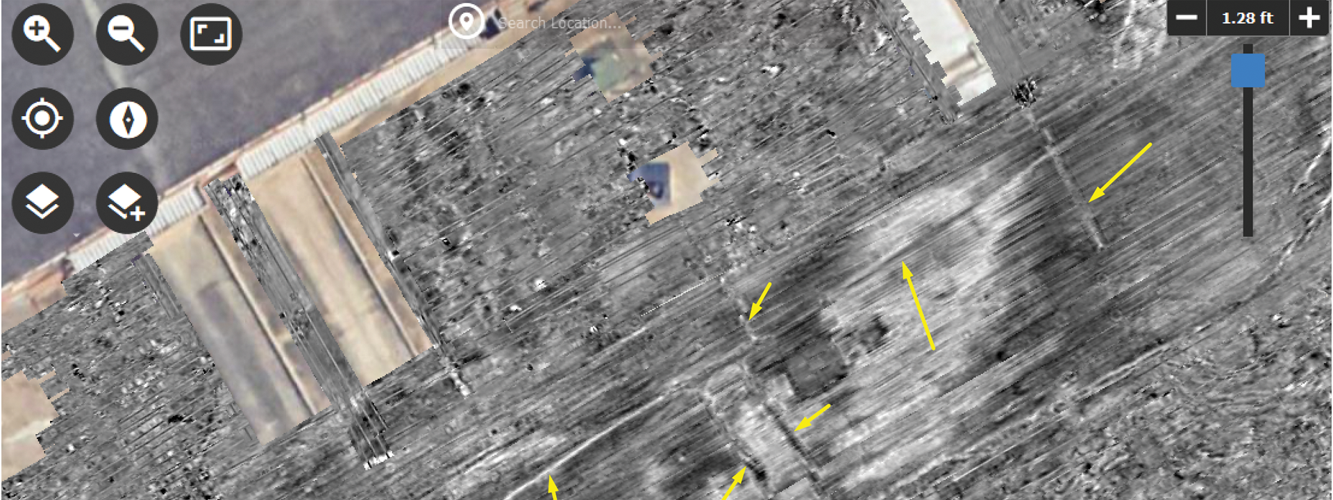
Advanced GPR data visualizations, such as time-slices (or depth-slices), fence diagrams, volumetric cubes, and isosurfaces, represent the cutting edge of subsurface mapping. While these sophisticated formats, including high-density point cloud data, traditionally required expert geophysicists to create using complex proprietary software, they are now more easily exportable to cloud-based GIS platforms after processing and visualization. This shift allows stakeholders to visualize 3D utility models and horizontal views of the subsurface from a top-down perspective, effectively distinguishing between closely spaced targets in congested areas while maintaining the expert-validated reliability necessary for high-stakes engineering decisions. These types of visuals also tend to be easier for non-users to understand and use compared to 1D trace or 2D GPR profiles since they are presented in a way more similar to traditional maps and actual subsurfaces.
Today, GPR, especially the high-productivity MCGPR, is transitioning from a specialized, last-resort service to a standard and integral component of comprehensive utility locating and SUE projects. Its role is to provide the high-resolution, verifiable 3D data necessary to mitigate risk in complex environments. While technological barriers related to software complexity and GPS integration have been largely reduced by GIS platforms, the necessity for human expertise in data validation remains paramount. The future of subsurface utility management lies not just in the technology, but in the seamless, accountable collaboration between GPR experts and project stakeholders, facilitated by transparent GIS environments that convert complex radar signatures into actionable, shared spatial intelligence.