
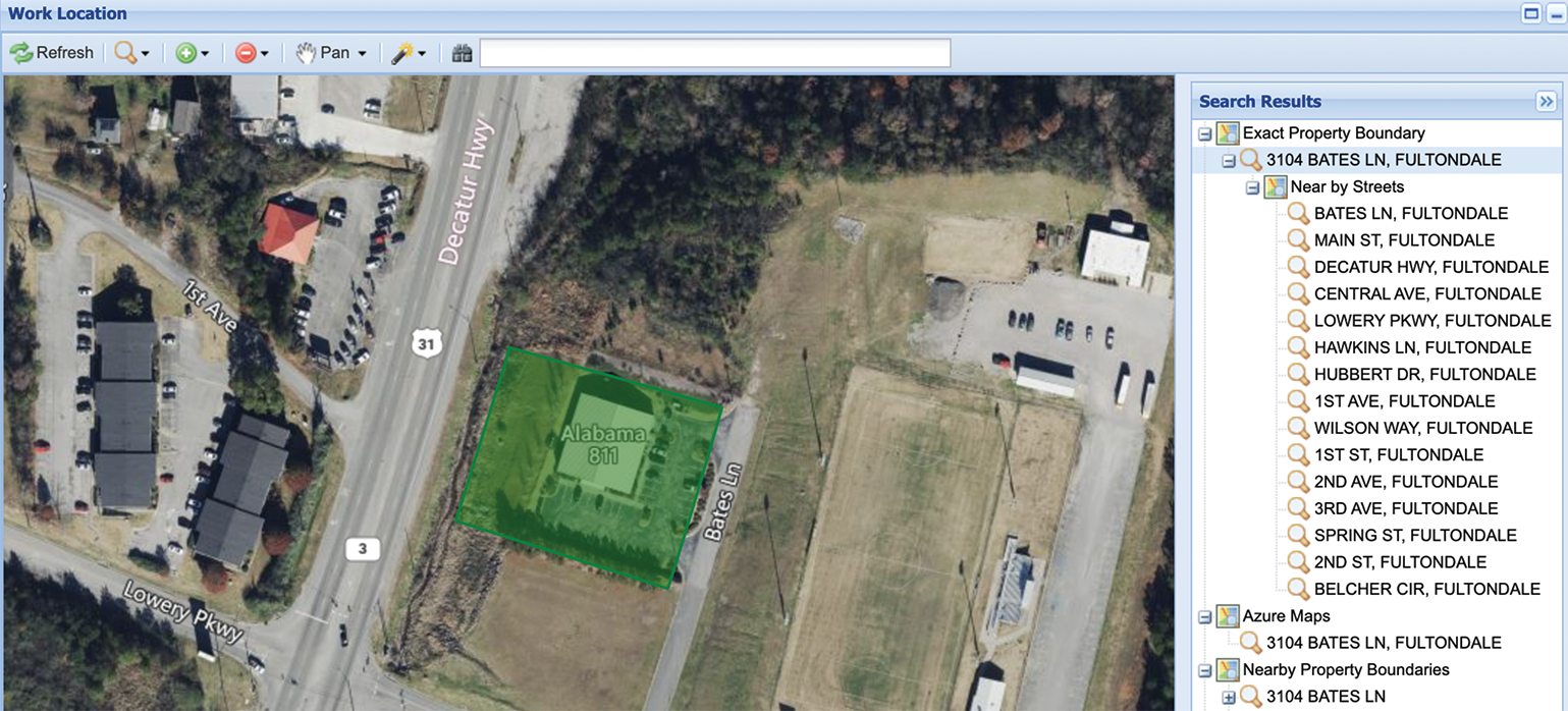
In the 811 environment, GIS is not a supporting tool—it is a foundational system that directly impacts daily operations, data accuracy, and member accountability. Every locate request, service area boundary, and utility responsibility is tied to geography.
GIS is key to defining, maintaining, and validating service area boundaries for utility members. These service areas determine how incoming locate tickets are distributed across the system. Even small spatial inaccuracies can result in challenges such as incorrect notification of members, duplicate notifications, or unnecessary workload for utility members. These issues don’t just impact efficiency—they introduce real-world risk in the field. GIS usage works to ensure that routing is accurate and consistent.
In many organizations, GIS is still viewed as a mapping or visualization tool. In 811, our take on GIS is slightly different. GIS is part of the operational backbone. Every ticket that comes into the system is spatially evaluated against member utility designated service area polygons. When a ticket is created, it becomes a polygon representing the area of intended excavation. That ticket polygon is then compared against all member service area polygons. Any service area that intersects that ticket polygon receives a notification. This process is happening constantly and must be fast, consistent, and reliable. This isn’t a static map—it’s a live system making decisions in real time. GIS in this environment is responsible for member notifications, maintaining boundaries, supporting audits, and enabling reporting.
GIS sits in the middle of everything, connecting ticketing systems, member records, and spatial data into one consistent framework. In most cases, utility members provide their data in shapefiles, GeoJSON, or KMZ formats. Data quality varies widely, and some rural utilities may not have usable spatial data at all. In those cases, GIS workflows can leverage billing system address data to help build their service area notification database. By converting billing records into spatial address points, GIS provides a repeatable and objective foundation for defining service areas. This approach fills gaps when traditional GIS data is missing and reduces reliance on manual methods.
Parcel data is one of the most important layers in the process to help determine the proposed excavation site. Many locate requests are tied to new development, where mapping and imagery lag behind. Aerial imagery can only show what already exists, not what has been recently assigned or planned. The issue often starts at address search during ticket creation. If the system cannot find the address, everything downstream is compromised. In new subdivisions, addresses may exist before they appear in mapping datasets. This can lead to approximated locations or over-notification from having to estimate the approximate location of the proposed excavation activity. Parcel data ensures new addresses are searchable early, allowing accurate ticket creation and routing.
Not all utilities maintain GIS data, especially in rural areas. Service areas may be built from paper maps or manual methods. This introduces inconsistency and makes updates difficult. GIS workflows can use road centerlines, billing-derived address points, and automation. These methods can achieve 75–95% accuracy with minimal input. Remaining gaps are typically due to missing features like private easements. Automation significantly reduces time and improves consistency.
As systems grow, manual GIS work does not scale. Automation generates service areas, validates spatial relationships, detects overlaps, and integrates updates. It ensures consistent logic is applied across the system. This is critical in statewide environments with multiple utilities. GIS accuracy directly impacts real-world outcomes. Incorrect service areas can lead to missed notifications and increased risk. Overly broad areas create unnecessary workloads. GIS provides a defensible spatial basis for routing and accountability.
GIS has expanded beyond mapping into data engineering, automation, and real-time analysis. It now directly impacts safety, efficiency, and reliability. It ensures accuracy, safety, and efficiency from ticket creation to completion. In an environment where precision matters, GIS is essential.
GIS sits in the middle of everything, connecting ticketing systems, member records, and spatial data into one consistent framework. In most cases, utility members provide their data in shapefiles, GeoJSON, or KMZ formats. Data quality varies widely, and some rural utilities may not have usable spatial data at all. In those cases, GIS workflows can leverage billing system address data to help build their service area notification database. By converting billing records into spatial address points, GIS provides a repeatable and objective foundation for defining service areas. This approach fills gaps when traditional GIS data is missing and reduces reliance on manual methods.
Parcel data is one of the most important layers in the process to help determine the proposed excavation site. Many locate requests are tied to new development, where mapping and imagery lag behind. Aerial imagery can only show what already exists, not what has been recently assigned or planned. The issue often starts at address search during ticket creation. If the system cannot find the address, everything downstream is compromised. In new subdivisions, addresses may exist before they appear in mapping datasets. This can lead to approximated locations or over-notification from having to estimate the approximate location of the proposed excavation activity. Parcel data ensures new addresses are searchable early, allowing accurate ticket creation and routing.
Not all utilities maintain GIS data, especially in rural areas. Service areas may be built from paper maps or manual methods. This introduces inconsistency and makes updates difficult. GIS workflows can use road centerlines, billing-derived address points, and automation. These methods can achieve 75–95% accuracy with minimal input. Remaining gaps are typically due to missing features like private easements. Automation significantly reduces time and improves consistency.
As systems grow, manual GIS work does not scale. Automation generates service areas, validates spatial relationships, detects overlaps, and integrates updates. It ensures consistent logic is applied across the system. This is critical in statewide environments with multiple utilities. GIS accuracy directly impacts real-world outcomes. Incorrect service areas can lead to missed notifications and increased risk. Overly broad areas create unnecessary workloads. GIS provides a defensible spatial basis for routing and accountability.
GIS has expanded beyond mapping into data engineering, automation, and real-time analysis. It now directly impacts safety, efficiency, and reliability. It ensures accuracy, safety, and efficiency from ticket creation to completion. In an environment where precision matters, GIS is essential.
GIS sits in the middle of everything, connecting ticketing systems, member records, and spatial data into one consistent framework. In most cases, utility members provide their data in shapefiles, GeoJSON, or KMZ formats. Data quality varies widely, and some rural utilities may not have usable spatial data at all. In those cases, GIS workflows can leverage billing system address data to help build their service area notification database. By converting billing records into spatial address points, GIS provides a repeatable and objective foundation for defining service areas. This approach fills gaps when traditional GIS data is missing and reduces reliance on manual methods.
Parcel data is one of the most important layers in the process to help determine the proposed excavation site. Many locate requests are tied to new development, where mapping and imagery lag behind. Aerial imagery can only show what already exists, not what has been recently assigned or planned. The issue often starts at address search during ticket creation. If the system cannot find the address, everything downstream is compromised. In new subdivisions, addresses may exist before they appear in mapping datasets. This can lead to approximated locations or over-notification from having to estimate the approximate location of the proposed excavation activity. Parcel data ensures new addresses are searchable early, allowing accurate ticket creation and routing.
Not all utilities maintain GIS data, especially in rural areas. Service areas may be built from paper maps or manual methods. This introduces inconsistency and makes updates difficult. GIS workflows can use road centerlines, billing-derived address points, and automation. These methods can achieve 75–95% accuracy with minimal input. Remaining gaps are typically due to missing features like private easements. Automation significantly reduces time and improves consistency.
As systems grow, manual GIS work does not scale. Automation generates service areas, validates spatial relationships, detects overlaps, and integrates updates. It ensures consistent logic is applied across the system. This is critical in statewide environments with multiple utilities. GIS accuracy directly impacts real-world outcomes. Incorrect service areas can lead to missed notifications and increased risk. Overly broad areas create unnecessary workloads. GIS provides a defensible spatial basis for routing and accountability.
GIS has expanded beyond mapping into data engineering, automation, and real-time analysis. It now directly impacts safety, efficiency, and reliability. It ensures accuracy, safety, and efficiency from ticket creation to completion. In an environment where precision matters, GIS is essential.